All areas of Dare County are now under a Tropical Storm Warning with a Flash Flood Watch and a Storm Surge Watch in effect. Residents, visitors and business owners are encouraged to take necessary steps now to secure property and ensure safety and preparedness prior to the arrival of tropical storm force winds, heavy rain and possibly 2-4 feet of above ground soundside flooding.
National Weather Service forecasters with the Newport/Morehead City Weather Forecast Office indicate that the current forecast track will bring southerly winds at near tropical storm strength that will transition to the southwest and then to the west as Michael moves rapidly across the region Thursday night into Friday morning. While the Storm Surge Watch covers all of Dare County, forecasters believe that any impacts from soundside flooding will be seen in areas of the county north of Avon. The National Hurricane Center’s Potential Storm Surge Flooding Map can be found at https://www.nhc.noaa.gov/ under Hurricane Michael Storm Surge Inundation link.
Dare County Emergency Management offers the following tips and resources:
-
As weather conditions worsen Thursday evening, travel only if absolutely necessary and stop if you encounter water covering the road. Turn around, don’t drown! It is never safe to drive or walk through flood waters because you will not know the depth of the water or the condition of the ground underneath.
FEMA Disaster Recovery Centers
All FEMA Disaster Recovery Centers in North Carolina will be closed Thursday, Oct 11 due to the impending storm. The centers will reopen when it is safe to open, possibly Friday.
Ferries revising schedule
Several of North Carolina’s coastal ferries will make one round trip Thursday morning before temporarily shutting down operations to prepare for the arrival of remnants from Hurricane Michael.
For the safety of passengers and ferry crews, the state’s ferries do not run during potentially unsafe weather conditions.
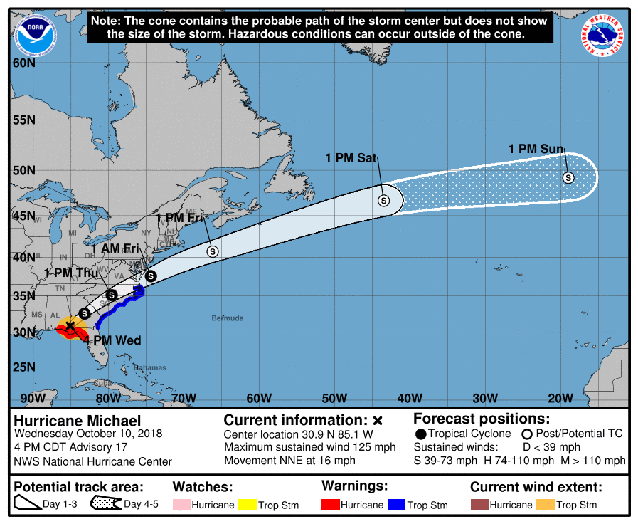
Remnants of Hurricane Michael, which made landfall near Mexico Beach, Fla. at 1:30 p.m. Wednesday, are expected to bring heavy rainfall and damaging winds (30-40 mph) to central and eastern North Carolina late Wednesday and all day Thursday.
The ferries between Ocracoke, Cedar Island and Swan Quarter will run on the following schedules Thursday morning:
- Cedar Island-to-Ocracoke Ferry will make runs at 7:30 a.m. and 10:30 a.m.
- Ocracoke-to-Cedar Island Ferry will make runs at 7:30 a.m. and 10:30 a.m.
- Ocracoke-to-Swan Quarter Ferry will make a run at 7 a.m. and then return to Ocracoke at 10 a.m.
After completing their runs, the ferries will be secured at their respective terminals until the storm passes. Officials with the North Carolina Ferry Division will announce when the ferries will resume operations.
Passengers can check on the status of the ferry route they want to use by contacting one of the ferry stations for that route on the NCDOT Ferry website.


 Loading ...