NC 12 group considers alternatives to fix route
Published 8:40 am Monday, July 5, 2021
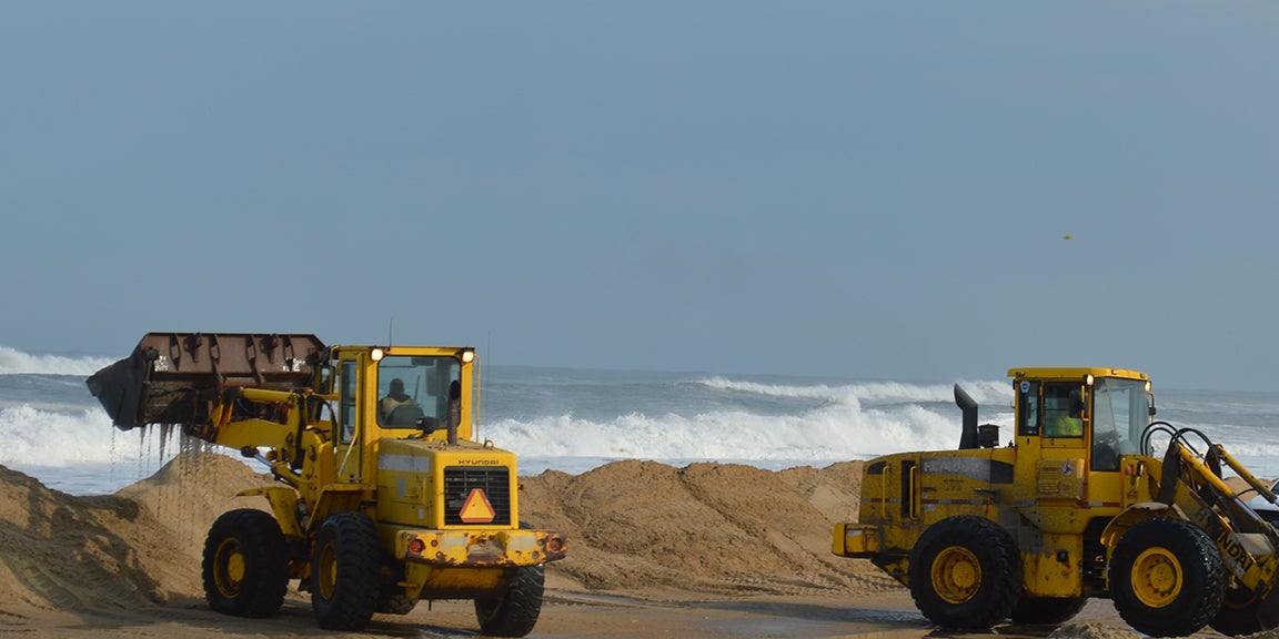
- At the infamous NC 12 S-turns north of Rodanthe, four NCDOT equipment operators shove sand back on the berm while large breakers hit the shore on Wednesday, September 23 around 5 p.m. Mary Helen Goodloe-Murphy photo
|
Getting your Trinity Audio player ready...
|
Dare County Board of Commissioners Chairman Robert L. Woodard and Cape Hatteras National Seashore Superintendent Dave Hallac are working together and with others to craft a long-term plan to address seven hot spots along NC 12 from Oregon Inlet to Ocracoke Village.
Woodard created the task force and chairs it. Hallac is vice chair of the group.
“We talk all the time,” said Woodard at the Rodanthe-Waves-Salvo Civic Association annual meeting. “We need a long-term plan on NC 12.”
Rodanthe is one of the seven hot spots that has a long range solution almost completed. The new Rodanthe bridge avoids NC 12’s famous S curves, noted for good surfing waves and dramatic photographs of ocean-bashed pavement and big yellow machines pushing back the ocean. The bridge is expected to be open in early 2022.
The work of the task force is to prioritize the remaining six hot spots – and any new ones that emerge – and find the money for multi-million dollar solutions.
To carry on with the work, a subcommittee with representatives from regulatory agencies has been established.
“The goal is to preserve access to Hatteras Island,” said Robert L. Outten, county manager and chair the subcommittee at the meeting held June 16, 2021 in Manteo.
Reide Corbett, who heads up the ECU Coastal Studies Institute, introduced a discussion about access. “Access to communities is different from access to corridors.”
Hallac ventured “access is not going to be the same.”
Another goal is to “make sure we know what our challenges are.” The subcommittee will help think through plans and get challenges on the table.
NC 12 has been studied by NCDOT. All but one of the hot spots has a feasibility study listing alternatives to maintain access to Hatteras and Ocracoke villages and egress to medical and government facilities, for example.
Instead of pushing sand back into linear dune lines, the studies offer beach nourishment (stand-alone or with bridges) and bridges in existing and outside easements.
NCDOT is sponsoring a new feasibility study that will cover from the southern end of the Oregon Inlet Bridge to the new Rodanthe bridge. The study will include the Canal Zone, which does not have a recent study and the Pea Island Visitor Center area that does not include the trouble spot at the actual visitor center.
The Hot Spots:
– The Canal Zone at the northern tip of Hatteras Island has towering dunes on the east and most of the west sides which trap water, making NC 12 a canal.
Initially, the area was bypassed in the Bonner Bridge replacement project, but it was not addressed due to “various hurdles.” No recent studies or recommendations are on the table.
– Pea Island Visitor Center. The short-term mitigation is “to use heavy equipment to push material back” into linear dunes. The three scenarios start at the southern end of the South Pond.
The proposals are to build a bridge 2.4 miles long in the existing easement at an estimated cost of $99.3 million; or venture into the Pamlico Sound and build on new locations marked as Alignment A about 5.14 miles long ($250.1 million) or Alignment B about 5.5 miles long ($267.3 million).
– Avon and north end of Buxton. Five alternatives are offered:
- Relocate NC 12, 245 to 300 feet to the west and build a 2.3 mile bridge, starting north of Haulover parking area and stopping just outside of the village. $81.1 million;
- Build a two-mile bridge in the existing easement, starting north of Haulover parking area and ending at Oramar Drive. $154.7 million;
- Build a 2.5mile bridge well out into Pamlico Sound landing in the vicinity of Rocky Rollinson Road. $345.4 million;
- Relocate NC 12 about 90 to 160 feet west for two miles and nourish beach. $16.8 million plus $115.6 million for nourishment. Total: $132.4 million;
- Nourish beach. $115.6 million.
– Frisco-Hatteras. A dune breach is expected as 500 feet of island separate the Atlantic Ocean from the Pamlico Sound.
- Relocate NC 12 west and build a ¾ mile bridge. $45.8 million.
- Relocate NC 12 west and build a mile-long bridge. $67.4 million.
- Build 1.5 mile bridge in existing alignment and beach nourish. Construction $77.6 million. Nourish beach $60.7 million. Total: $138.3 million.
- Stay in existing alignment and beach nourish. $84.7 million.
– Ocracoke: The subcommittee expanded the scope to include NC 12 from the Ocracoke’s ferry terminal to three miles south from the ferry dock. Costs are expected to range from $6 million to $500 million.
A project has recently been submitted to NCDOTs for prioritization that would relocate the ferry terminal to somewhere around Ocracoke’s pony pens. The location would avoid the trouble spot but increase travel time to Ocracoke from Hatteras. The estimated cost is $52.7 million.
NC 12 Task Force Charter
“Collaboratively develop a long-term, prioritized transportation plan for Highway 12 that identifies vulnerable highway locations (a.k.a. hotspots), projects future challenges related to erosion, storms, and sea level rise, refines and recommends location-specific solutions, and identifies funding strategies and a timeline for implementation.”
Partners are Dare County, Hyde County, Cape Hatteras National Seashore, Pea Island National Wildlife Refuge and North Carolina Department of Transportation.
Subcommittee Members
Dare County: Robert L. Outten, Dare County manager and attorney, serves as chairman
Ocracoke: Bob Chestnut
Hatteras Island: Danny Couch, commissioner
U.S. Fish and Wildlife Service
Cape Hatteras Electric Cooperative, serving Hatteras Island
Tideland Electric Cooperative, serving Ocracoke
Southern Environmental Law Center: Kym Hunter
NC Division of Coastal Management
NC Wildlife Resources Commission
U.S. Fish and Wildlife Service
Coastal Studies Institute
U.S. Corps of Engineers
NC Division of Water Resources
NC Division of Marine Fisheries
NOAA National Marine Fisheries
NCDOT Ferry Division
NC 12 Task Force Members attending the first meeting of the subcommittee: Dave Hallac, Cape Hatteras National Seashore; Kris Noble, Hyde County manager; Win Bridgers, NCDOT
NC 12 subcommittee meeting schedule
Meetings are held in the Dare County Administration Building, located at 954 Marshall C. Collins Dr. in Manteo.
Tuesday, July 13, 2021, 11 a.m., Room 238. At conclusion of this meeting, the group will travel to each of the seven NC 12 hot spots.
Wednesday, Aug. 11, 2021, 11 a.m., Room 168
Wednesday, Sept. 8, 2021, 11 a.m., Room 168
Wednesday, Oct. 13, 2021, 11 a.m., Room 238

RECENT HEADLINES:
William Ray named new North Carolina emergency management director
Tyson Foods recalls nearly 8.5M lbs. of ready-to-eat chicken due to possible listeria contamination
More News

-
Polls
 Loading ...
-
-