West side of Oregon Inlet ‘completely shoaled’
Published 6:21 pm Friday, May 20, 2022
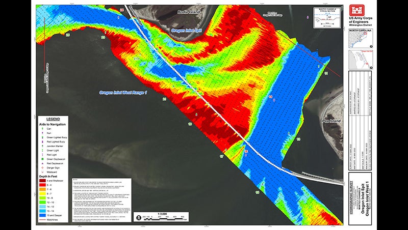
- Oregon Inlet survey made on May 17. Courtesy U.S. Army Corps of Engineers
|
Getting your Trinity Audio player ready...
|
Part of the Oregon Inlet channel west of the Marc Basnight Bridge is “completely shoaled,” reports the U.S. Army Corps of Engineers Wilmington District.
A May 17 Corps survey shows water depth of two to three feet between Buoys 17 and 21 at mean low water.
The survey was conducted in response to the intense nor’easter that impacted the Outer Banks during week of May 8.
The Corps announcement indicates that the “shallow depths of the current channel will not permit use of the USACE Shallow Draft Fleet dredges to clear the channel.”
For example, the Corps sidecaster dredge Merritt requires four feet of water to work.
The information released by the Corps states “the current channel markers will be removed in the coming days.”
The U.S. Coast Guard’s Marine Safety Information Bulletin follows up: “As such, Oregon Inlet Buoy 17 (LLNR 28055) will be temporarily disestablished and Oregon Inlet Channel Buoy 21A (LLNR 28073) will be discontinued. Oregon Inlet Lighted Buoy 19 (LLNR 28065) and Oregon Inlet Channel Buoy 21 (LLNR 28070) will be re-positioned to the northeast to mark good water.”
The May 20 bulletin continues: “The Coast Guard is not closing or otherwise restricting the waterway. Boaters choosing to transit through this channel do so at their own risk and should use extreme caution,” states the U.S. Coast Guard.
“The Coast Guard and U.S. Army Corps of Engineers are currently coordinating and actively investigating other potential areas where a marked channel can be established to provide access to and from Oregon Inlet.”
Additionally, the marked channel at the Oregon Inlet bar is showing signs of shoaling. Water depth is four to five feet.
In Hatteras Inlet, the Hatteras Connector held up well during the May 8-12 nor’easter.

More News


-
Polls
 Loading ...
-
-