New interactive tool shows maps about marine fisheries rules
Published 12:06 pm Monday, July 18, 2022
- Courtesy North Carolina Division of Marine Fisheries
|
Getting your Trinity Audio player ready...
|
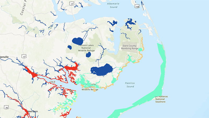
The North Carolina Division of Marine Fisheries has launched a new interactive mapping tool to assist the public with finding and using maps associated with rules.
The Common North Carolina Marine Fisheries Commission Rules application replaces the old, static maps and is useful to both commercial and recreational fishermen. Among the included maps are:
- Anadromous Fish Spawning Areas
- Demarcations of Coastal, Joint and Inland Fishing Waters
- Crab Spawning Sanctuaries
- Designated Pot Areas
- Fish Nursery Areas
- Gill Net Attendance Areas
- ITP Management Areas
- Mechanical Clam Harvest Areas
- Military Danger Zones and Restricted Areas
- Sea Turtle Sanctuaries
- Striped Bass Management Areas
- Shrimp Trawl Prohibited Areas and
- Trawl Net Prohibited Areas
The application allows the user to layer the maps and zoom in and out on specific water bodies. The user can measure by distance and area and find latitude and longitude. The maps can be viewed and printed from a computer screen or viewed on a smartphone.
The Common MFC Rules app is the latest in a number of marine fisheries interactive mapping tools that can be found on a geospatial hub North Carolina Marine Fisheries (arcgis.com) linked on the division’s website. The geospatial hub is a one-stop webpage where the public can link to all the Division of Marine Fisheries interactive maps available to the public, including:
- The Artificial Reef Interactive map
- N.C. Weigh Stations and Carcass Collection Locations
- The Shellfish Leasing Tool and
- The Shellfish Sanitation Temporary Closure Public Viewer.
The interactive maps and geospatial hub are part of ongoing efforts by the Division of Marine Fisheries to make fisheries information more accessible to the public.

More On the Water


-
Polls
 Loading ...
-
-