Hurricane Fiona: Coastal flood, high surf advisories issued, big swells expected
Published 5:47 pm Wednesday, September 21, 2022
- NOAA image
|
Getting your Trinity Audio player ready...
|
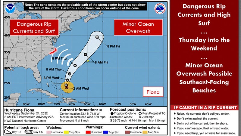
The National Weather Service has issued coastal flood and high surf advisories for Hatteras and Ocracoke Islands starting at 5 p.m., Thursday afternoon Sept. 22, 2022 and running through 8 p.m. Friday evening.
For the coastal flood advisory, the weather service expects one to two feet of inundation above ground level in low-lying areas near shorelines and tidal waterways.
For the high surf advisory, large breaking waves of six to 10 feet are expected in the surf zone.
While it is forcast to remain well offshore, swells from major Hurricane Fiona will bring dangerous surf to beaches from Cape Lookout north to Oregon Inlet, reports the weather service. Seas build to five to eight feet by late Thursday morning and then six to 10 feet by Thursday evening with seas remaining above eight feet until Friday evening.
Minor ocean overwash will also be possible across oceanside beaches including Rodanthe, Hatteras and Ocracoke.
Do not drive around barricades or through water of unknown depth. Take the necessary actions to protect flood-prone property.
Inexperienced ocean swimmers should remain out of the water due to dangerous surf conditions.
For the Outer Banks northern beaches, the National Weather Service has issued a high surf advisory from 2 a.m. to 8 p.m. on Friday, September 23, 2022. The weather service warns of large swells from Hurricane Fiona bringing dangerous swimming and surfing conditions and localized beach erosion.
More News


-
Polls
 Loading ...
-
-