Dare GIS Department creates OBX Days Gone By interactive map
Published 7:20 am Thursday, November 17, 2022
- Courtesy Dare County
|
Getting your Trinity Audio player ready...
|
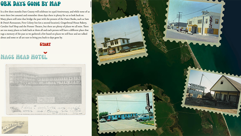
The Dare County GIS Department created an OBX Days Gone By interactive map in celebration of Geographic Information Systems (GIS) Day, which took place on Wednesday, November 16, 2022. The interactive map gives users an opportunity to explore various unique locations along the Outer Banks and to learn more about the area’s history that spans several centuries.
“Whether you are a lifelong resident of Dare County or a visitor who has vacationed on the Outer Banks for many years, you will undoubtedly discover a wide array of popular places you may have visited in the past on this map that serves up a sense of nostalgia for days gone by,” stated a Dare County press release announcing the new map.
The interactive map – which features historic locations such as the very first hotel to ever be constructed along the shoreline in 1838, the long-since-sand-covered Jockey’s Ridge Miniature Golf course, the Nags Head Casino, the Carolinian, Quagmire’s and Mex-Econo’s – provides users a chance to reminisce about some of their favorite places to spend time with family and friends over the years.
“In addition to historic places that date back several decades, the OBX Days Gone By map also features a series of iconic local hot spots that younger generations of residents and visitors will fondly remember, such as Dowdy’s Amusement Park, Kelly’s Tavern, Port O’ Call and The Pit, among many others,” stated the release.
To view the OBX Days Gone By interactive map, go to gis.darecountync.gov/gisday/2022/.
GIS is a system that allows users to create, manage, analyze, map and visualize the world by connecting the “what” with the “where.” GIS also allows people to more easily identify patterns, relationships and geographic context in order to better influence decision-making, increase efficiency and improve communication.
For additional Dare County mapping resources, including past years’ GIS Day maps, go to gis.darecountync.gov.
SUBSCRIBE TO THE COASTLAND TIMES TODAY!

More News


-
Polls
 Loading ...
-
-