National Weather Service issues coastal flood warning, multiple weather advisories
Published 11:23 pm Thursday, December 22, 2022
- NOAA image
|
Getting your Trinity Audio player ready...
|
Portions of Dare County are expected to experience coastal flooding, gusty winds, possible ocean overwash, record low temperatures and hazardous marine conditions beginning Friday, Dec. 23, 2022 and lasting through Saturday, Dec. 24, 2022 as a result of a strong storm system that will impact our area, reports a media release from Dare County.
The National Weather Service at Newport/Morehead City has issued a coastal flood warning, as well as a high wind advisory, a high surf advisory and a wind chill advisory. Gale warnings are also in place for coastal waters.
Coastal Flood Warning
The coastal flood warning is in effect from 7 a.m. on Friday, Dec. 23 through 9 a.m. on Saturday, Dec. 24. Two to four feet of above ground soundside inundation is expected in low lying areas near shorelines and tidal waterways.
Vulnerable oceanfront areas are most at risk and residents and visitors in those areas should be ready to take action to protect property.
Ocean overwash should be expected at vulnerable beachfront properties and roadways around the time of high tide beginning Friday, Dec. 23 and persisting into Saturday, Dec. 24. Morning high tide on Friday is around 7:30 a.m. and at night around 7:45 p.m.
NC 12 on Hatteras Island may see ocean overwash that impacts travel. Oceanfront properties on the north end of Rodanthe that have experienced overwash are particularly vulnerable.
Residents and visitors in this area should be prepared for flooding, reports Dare County.
High Wind and High Surf Advisories
High wind and high surf advisories are also in effect. West winds at 25 to 35 miles per hour with gusts of up to 50 are expected Friday, Dec. 23 from 7 a.m. to 6 p.m.
The west wind will continue into the weekend, making soundside flooding a threat from Kitty Hawk to Hatteras Island, including Roanoke Island, well into late Saturday. Flood waters may impact travel on roads that flood with persistent westerly winds. Travel through flooded roads should be avoided.
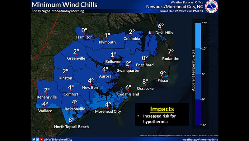
Wind Chill Advisory
The National Weather Service has also issued a wind chill advisory for Dare County, effective from 7 a.m. on Friday, Dec. 23 to 9 a.m. on Saturday. Artic air will push into the region, reducing temperatures to possible record lows. These temperatures coupled with high winds could lower the wind chill into the single digits.
With power outages a possibility, everyone should prepare winter clothes and warm blankets. Check heating systems and pipes for insulation now to help avoid impacts as temperatures drop. As temperatures drop, keeping a slow flow of water in faucets may help keep uninsulated pipes from freezing. Caution is advised when traveling outside during this time.
Dare County Emergency Management strongly encourages everyone in Dare County to keep up with the most up-to-date weather information via the National Weather Service at Newport/Morehead City at weather.gov/mhx and share the potential impacts with those visiting the Outer Banks.
For updated information regarding road conditions on N.C. Highway 12, follow the North Carolina Department of Transportation on Facebook a facebook/ncdotnc12 or visit drivenc.gov.
Have a NOAA weather radio, a mobile device with emergency alerts turned on or another means to receive National Weather Service alerts to be able to take action should further watches and warnings be issued.
SUBSCRIBE TO THE COASTLAND TIMES TODAY!

More News


-
Polls
 Loading ...
-
-