Tropical Storm Watch issued; time to prepare
Published 6:39 pm Tuesday, October 9, 2018
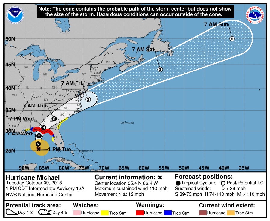
- NOAA image of Hurricane Michael's path.
As of 5 p.m. Tuesday, a tropical storm watch is in effect for Dare County indicating that tropical storm conditions are possible within the next 36 hours.
According to the National Weather Service, tropical force winds, rain and moderate soundside flooding will impact Dare County beginning Thursday evening into Friday morning as Hurricane Michael tracks through the southeastern U.S. following landfall in the Florida Panhandle on Wednesday.
As the storm approaches Dare County on Thursday, there will be a chance of tornadoes. The threat of rip currents is already high and will remain elevated until well after the storm passes through. Stay out of the ocean as conditions are dangerous for even the most experienced swimmers.
Dare County Emergency Management is reminding residents and visitors to go ahead and make necessary preparations – secure outdoor furniture, garbage cans and other loose, lightweight objects before the onset of strong winds and heavy rain. Motorists are advised to minimize travel as road conditions may become hazardous during periods of high winds and heavy rain.
Continue to monitor weather reports and be aware of any updated watches and warnings issued by the National Weather Service (NWS). For local weather conditions, visit http://www.weather.gov/mhx. For updated information from the National Hurricane Center, visit http://www.nhc.noaa.gov.
More BREAKING NEWS


SportsPlus
October 17 NHL TV Schedule: TV Channel, Start Times & Live Streaming Options
The Vegas Golden Knights versus the Tampa Bay Lightning is one of many compelling options on today’s NHL…
Will Dylan Strome Score a Goal Against the Stars on October 17?
On Thursday at 7:00 PM ET, the Washington Capitals clash with the Dallas Stars. Is Dylan Strome going…
Will Alexander Ovechkin Score a Goal Against the Stars on October 17?
Will Alexander Ovechkin light the lamp when the Washington Capitals take on the Dallas Stars on Thursday at…
Will Tom Wilson Score a Goal Against the Stars on October 17?
Should you wager on Tom Wilson to find the back of the net when the Washington Capitals and…
Will Connor McMichael Score a Goal Against the Stars on October 17?
The Washington Capitals’ upcoming contest versus the Dallas Stars is set for Thursday at 7:00 PM ET. Will…
-
Polls
 Loading ...
-
-