Outer Banks under Hurricane and Storm Surge watches; Dorian still on track to move over or near coast
Published 6:53 am Wednesday, September 4, 2019
- NOAA image
The Outer Banks area is under both a Hurricane Watch and a Storm Surge Watch.
As of the 5 a.m. National Hurricane Center update on September 4, tropical storm conditions are currently affecting portions of the northeastern coast of Florida, and should begin along the Georgia coast later this morning.

NOAA image
Interests elsewhere along the Mid-Atlantic coast of the United States should continue to monitor the progress of Dorian, as additional watches or warnings may be required later Wednesday.
The NHC advises water could reach the following heights above ground somewhere in the indicated areas if the peak surge occurs at the time of high tide:
Isle of Palms to Myrtle Beach, SC…5 to 8 ft.
Savannah River to Isle of Palms SC…4 to 7 ft.
Myrtle Beach to Cape Lookout…4 to 7 ft.
Cape Lookout to Duck including Pamlico and Albemarle Sounds and the Neuse and Pamlico Rivers…4 to 6 ft.
Volusia/Brevard County Line, Fla. to Savannah River…3 to 5 ft.
Sebastian Inlet, Fla. to Volusia/Brevard County Line, Fla….2 to 4 ft.
Duck to Poquoson Va., including Hampton Roads…2 to 4 ft.

NOAA image
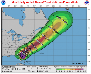
Hurricane Dorian is centered as of 5 a.m. about 90 miles east of Daytona Beach, Fla. Dorian is moving toward the north-northwest near 8 mph, and a northwest or north-northwest motion is expected through this morning. A turn toward the north is forecast by this evening, followed by a turn toward the north-northeast on Thursday morning. On this track, the core of Hurricane Dorian will move dangerously close to the Florida east coast and the Georgia coast through tonight. The center of Dorian is forecast to move near or over the coast of South Carolina and North Carolina Thursday through Friday morning.
Maximum sustained winds are near 105 mph with higher gusts. Hurricane-force winds extend outward up to 60 miles from the center, and tropical-storm-force winds extend outward up to 175 miles. Some weakening is expected during the next couple of days, however Dorian is expected to remain a powerful hurricane during the next few days.
NOAA image
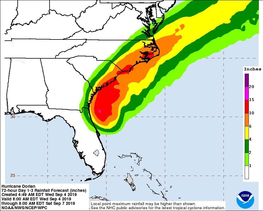
Dorian is expected to produce the following rainfall totals through Friday:
Coastal Carolinas…5 to 10 inches, isolated 15 inches.
Atlantic Coast from Daytona Beach, Florida to the Georgia-South Carolina line…3 to 6 inches, with isolated 9 inches near the Georgia coast.
Southeast Virginia…3 to 6 inches.
READ ABOUT MORE NEWS AND EVENTS HERE.
RECENT HEADLINES:
More News


SportsPlus
Will Chuba Hubbard Play in Week 4? NFL Injury Status, News & Updates
Chuba Hubbard was a limited participant in his most recent practice. The Carolina Panthers’ Week 4 game against…
Will Diontae Johnson Play in Week 4? NFL Injury Status, News & Updates
All of Diontae Johnson’s stats can be found on this page. In terms of season stats, Johnson has…
Will Andy Dalton Play in Week 4? NFL Injury Status, News & Updates
Andy Dalton was a full participant in his most recent practice, and should play when the Carolina Panthers…
Best Bets, Predictions & Odds for the Norfolk State vs. North Carolina Central Game – Saturday, Sept. 28
The North Carolina Central Eagles (2-2) play the Norfolk State Spartans (2-3) at Lucas Oil Stadium in Indianapolis,…
How to Watch the Orioles vs. Twins Game: Streaming & TV Channel Info for Sept. 28
Carlos Santana and the Minnesota Twins square off against Colton Cowser and the Baltimore Orioles on Saturday at…
-
Polls
 Loading ...
-
-