Dare County Emergency Management advising it is too late to evacuate; shelter in place
Published 7:12 pm Thursday, September 5, 2019
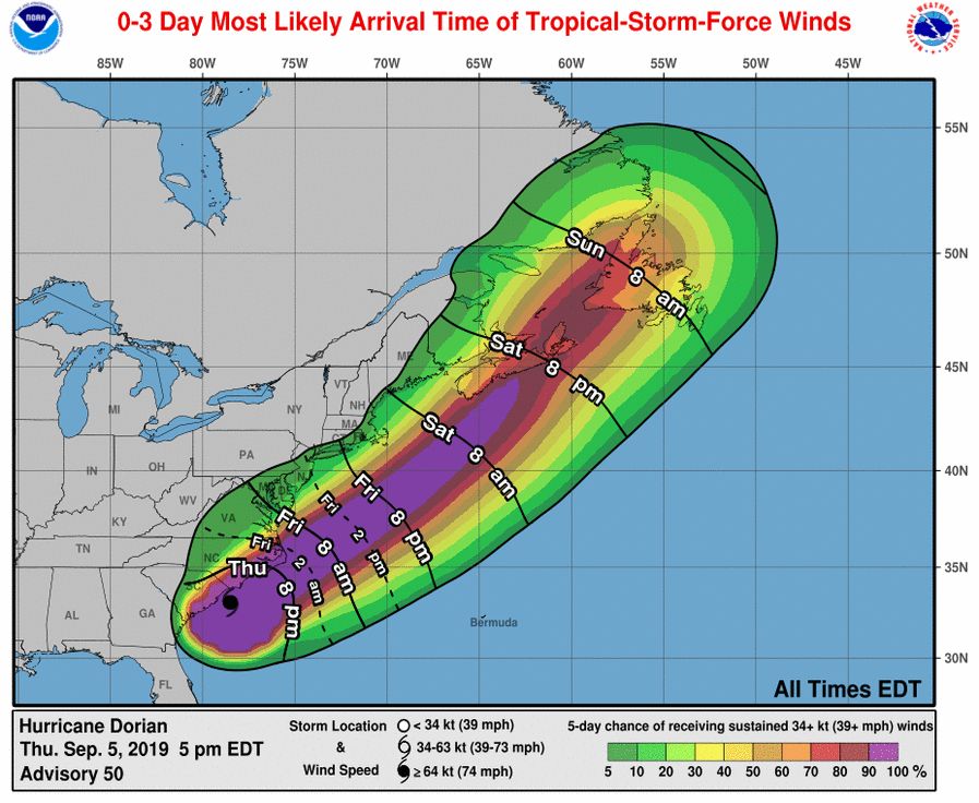
- NOAA image
Dare County Emergency Management has advised in their 7 p.m. update on Thursday, September 5 that time to safely evacuate has passed and that those still in Dare County should shelter in place until the storm passes. Conditions will deteriorate overnight and remain hazardous through Friday afternoon.
Curfews for all areas of Dare County, except for the Town of Kitty Hawk, will begin at 8 p.m. Thursday and be in place until noon on Friday. This curfew may be extended based on conditions.
Access to Dare County will be restricted at 8 p.m. with law enforcement stationed at checkpoints.
According to the National Weather Service:
Storm surge from ocean and soundside flooding is estimated at four to seven feet above the ground, not including wave action. Ocean flooding will increase Thursday night and continue through Friday night. Soundside flooding is forecasted to begin late Friday morning through Friday afternoon, as the storm passes and winds shift direction.
Winds are forecasted to reach 70 to 95 mph with gusts to 110 mph. Winds will increase overnight and are forecasted to reach hurricane force early Friday morning and remain in areas of the county through midday Friday.
Rainfall of 6 to 12 inches is forecasted through Friday afternoon with locally higher amounts possible.
Tornadoes are possible as Hurricane Dorian approaches, mainly Thursday evening.
Monitor updated local weather forecasts, watches and warnings from the National Weather Service at www.weather.gov/mhx.
Visit www.darenc.com/hurricanedorian for updated information from Dare County, the towns of Duck, Southern Shores, Kitty Hawk, Kill Devil Hills, Nags Head and Manteo as well as the National Park Service, Outer Banks Group.
READ ABOUT MORE NEWS AND EVENTS HERE.
More News


SportsPlus
Chiefs, 49ers, Week 5 NFL Power Rankings
Heading into Week 5 of the NFL schedule, let’s dig into our freshly updated power rankings, which dissect…
Discover the Best Week 5 NFL Player Prop Bets & Odds
The New Orleans Saints versus the Kansas City Chiefs is a game to catch on a Week 5…
Orioles vs. Royals: Betting Preview for AL Wild Card Game 1
Game 1 of the Wild Card round is set for Tuesday, Oct. 1 at Oriole Park at Camden…
How to Watch the MLB Baseball Playoffs on Tuesday, Oct. 1: TV Channel, Live Streaming, Start Times
The MLB Playoff outings in a Tuesday lineup that shouldn’t be missed include the New York Mets squaring…
How to Watch the Orioles vs. Royals Game: Streaming & TV Channel Info for AL Wild Card Game 1
The AL Wild Card Series begins on Tuesday when the Baltimore Orioles play host to the Kansas City…
-
Polls
 Loading ...
-
-