Dare establishes curfew; no entry to county beginning at 8 p.m. Thursday
Published 10:37 am Thursday, September 5, 2019
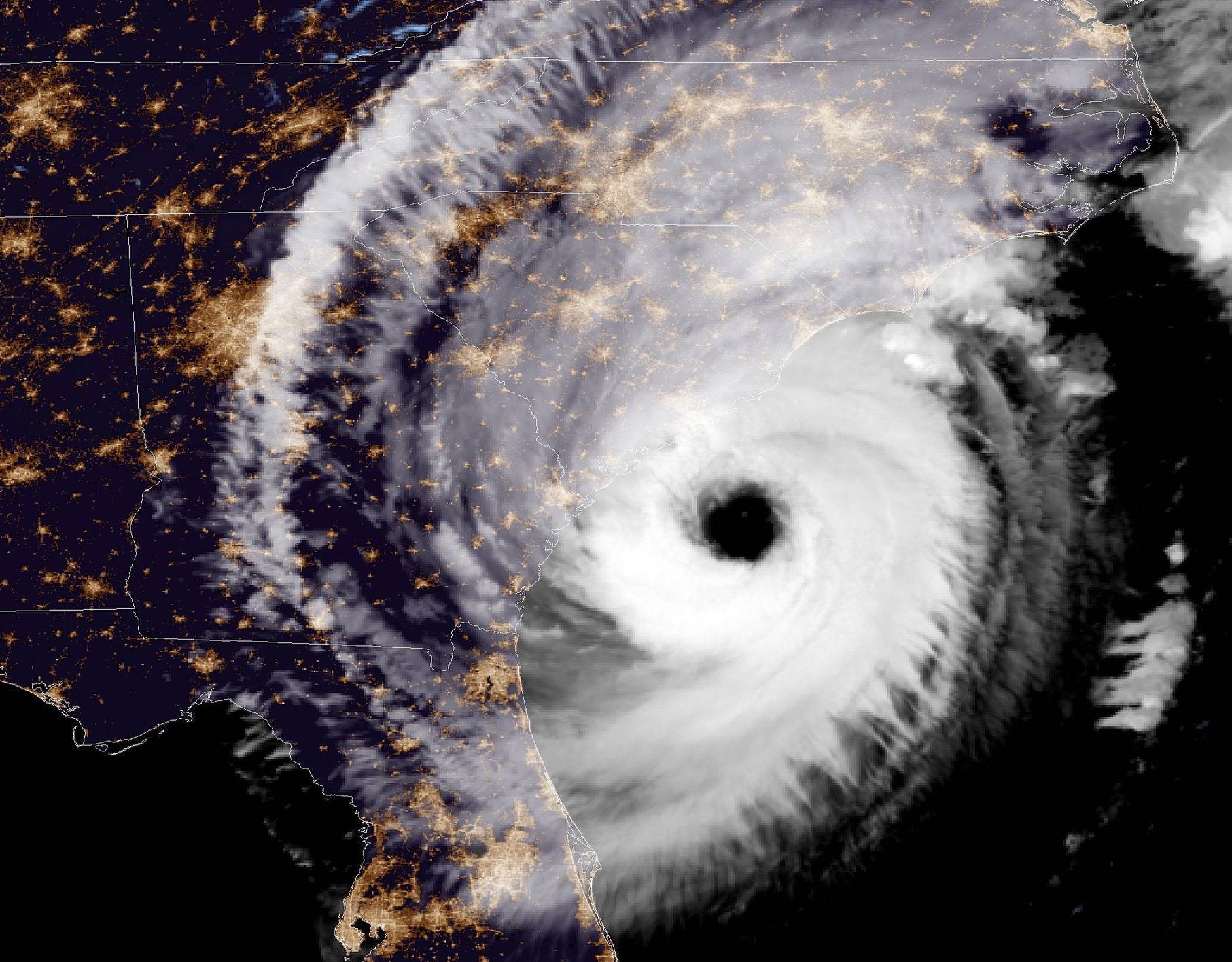
- NOAA image
Dare County Emergency Management has released a statement reminding those in the area that the window of opportunity for evacuation is closing. They strongly warn everyone “to evacuate immediately to ensure the safety of you and your family.”
North Carolina Emergency Management has opened shelters in other areas of the state, including pet-friendly locations. For updated shelter information, visit https://www.ncdps.gov/storm-
Storm surge from ocean and soundside flooding is now estimated at four to seven feet above the ground, not including wave action. According to the National Weather Service, there will be periods of rapid water rise from the soundside as the storm passes, possibly into Friday evening.
There will be no access into Dare County beginning 8 p.m. on Thursday.
Curfews have been established for all areas of Dare County except the Town of Kitty Hawk beginning at 8 p.m. Thursday through noon on Friday. This curfew may be extended based on conditions. No curfews have been established for the Town of Kitty Hawk.
The Dare County Emergency Management release states that Hurricane Dorian will bring life-threatening impacts to Dare County. Extreme ocean and soundside flooding, heavy rain and hurricane force winds are forecasted. Roads will become unsafe for travel and some areas will become inaccessible. Highway 12 on Hatteras Island is especially vulnerable to flooding and will likely become compromised and impassable.
Power outages are likely for an extended period of time. To view storm surge estimates for your particular area, visit the National Hurricane Center’s storm inundation map http://bit.ly/StormSurgeOBX. Rainfall totals are estimated at eight to ten inches with up to 15 locally in some areas. In addition, winds are expected to reach hurricane force at the height of the storm.
Dare County remains under a Hurricane Warning and a Storm Surge Warning. A Flash Flood Watch is in effect through 8 p.m. Friday. A Tornado Watch is in effect through 7 p.m. Thursday. Monitor updated local weather forecasts, watches and warnings from the National Weather Service at www.weather.gov/mhx.
The ban on ocean swimming remains in place until further notice. Stay out of the water as it is unsafe for even the most experienced swimmers.
The next update from Dare County Emergency Management will be issued when necessary to provide critical, storm-related information.
Visit www.darenc.com/hurricanedorian for updated information from Dare County, the towns of Kitty Hawk, Southern Shores, Kill Devil Hills, Nags Head and Manteo as well as the National Park Service, Outer Banks Group.
Subscribe to receive emergency alerts via text, email or phone from Dare County Emergency Management at www.DareNC.com/alerts and follow @DareCountyEM on Twitter.
READ ABOUT MORE NEWS AND EVENTS HERE.
RECENT HEADLINES:
All North Carolina coastal waters closed to shellfish harvest
More Uncategorized

SportsPlus
Best Bets, Predictions & Odds for the Old Dominion vs. Georgia Southern Game – Thursday, Oct. 24
Sun Belt opponents will clash when the Old Dominion Monarchs (3-4) battle the Georgia Southern Eagles (5-2). Below,…
Old Dominion vs. Georgia Southern: Odds, spread, and over/under – Oct. 24
Sun Belt play pits the Old Dominion Monarchs (3-4) against the Georgia Southern Eagles (5-2) on Thursday, October…
Where to Watch Philadelphia Flyers vs. Washington Capitals on TV or Streaming Live – October 22
NHL action on Tuesday includes the Philadelphia Flyers (1-3-1) hosting the Washington Capitals (3-1) at Wells Fargo Center,…
Sun Belt Football Predictions, Computer Picks & Best Bets | Week 9
If you are looking for information on the best bets in Sun Belt action in Week 9, or…
Flyers vs. Capitals Injury Report Today – October 22
Ahead of their Tuesday, October 22 matchup with the Washington Capitals (3-1) at Wells Fargo Center, which starts…
-
Polls
 Loading ...
-
-