Rodanthe bridge detailed; questions raised
Published 11:00 am Sunday, October 6, 2019
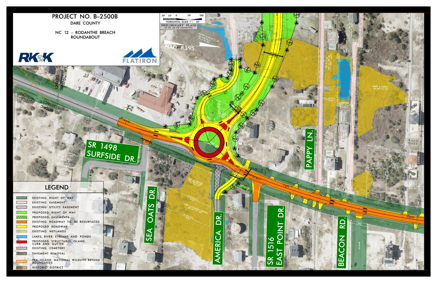
- The at the intersection of existing NC 12 and the new Rodanthe Bridge, which avoids the S-curves in the Pea Island National Wildlife Refuge.
The new 2.3-mile Rodanthe Bridge will be ready for traffic in early 2021. It’s roughly 20 percent complete.
About a year from now, the north end construction will meet south end construction in the middle. About 75 people are now working on the bridge – a number that will rise to 110 to 125 bridge workers.
NCDOT held a community update meeting Sept. 26 at the Rodanthe-Waves-Salvo Community Building.
NCDOT resident engineer Pablo Hernandez delivered an informational update and then fielded mostly hostile, combative questions for more than 90 minutes.
In late 2016, Flatiron Constructors was awarded a design-build contract with a $145.33 million bid. To date, $65 million has been spent.
Distance between bents or pilings is mostly 140 feet. At the curves, the distance is 95 feet. Pilings are driven to a depth between 140 to 160 feet.
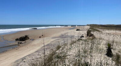
The bridge, when it is running parallel to the shoreline, will be between 1,000 and 1,200 feet from the shore.
At the completion of the bridge project, the contractor will remove the asphalt from the southern boundary of Pea Island National Wildlife Refuge to the northern terminus of the Rodanthe Bridge and NCDOT will return the NC 12 easement to the refuge.
In 2014, a temporary beach nourishment project with associated sandbags was implemented to help keep NC 12 open until a long‐term solution, namely the Rodanthe Bridge, could be built. The sandbags extend 1.5 miles into the refuge from the boundary.
As part of the contract, the temporary sandbags lining the ocean side of NC 12 in the refuge will be removed as NC 12 protection will no longer be needed. The area in the refuge will be allowed to function naturally as wildlife habitat.
The project’s Record of Decision states there are no plans to repeat a beach nourishment project.
At the meeting, some speakers insisted that sandbags be extended in front of Mirlo Beach oceanfront properties.
Staffers from the refuge, NCDOT and the Cape Hatteras Electric Cooperative continue to work together on the project. The cooperative’s transmission lines will be moved to the new Rodanthe Bridge. The cooperative is reducing the size of its easement through the refuge and leaving its poles in place in case of an emergency.
Another issue hammered on was the height of the bridge now under construction.
In a follow-up phone call, Hernandez refined figures.
The driving surface is 25.3 feet above the water. To that figure is added a three-foot concrete side plus two feet of metal railing, like the new Marc Basnight Bridge. The height of the structure is 30.5 feet. The two travel lanes will be 12 feet wide with eight-foot shoulders, again like the new Marc Basnight Bridge.
A commitment makes the height between mean high water (one foot) and the beginning of the bridge understory 17 feet.
Pappy Lane, an unimproved road, is directly to the north of the bridge construction. Pappy Lane property owner Mark Haines asked for action on these issues: clean up trash from the shoreline (started Friday morning, Sept. 27) and address flooding on Pappy Lane.
Haines asked for better communications regarding when pile driving occurs. “Someone needs to be more in touch with the local community,” said Haines.
A month-long action plan is posted on the NCDOT’s website. Driving pilings can occur seven days a week between 8 a.m. and 9 p.m.
Hernandez, in the phone call, described the permanent bridge construction process as a “moving assembly line” and building the trestle bridge as “leap frogging.” Operations on one part of the project may delay other action, like driving piles.
Haines questioned why the early start time at 6:30 a.m. Hernandez responded it is due to the summer heat.
Haines charged that it wasn’t safe to come down Pappy Lane as the public is doing to watch the construction. Haines asked for the road to be closed.
Regarding the Pappy Lane wreck researched by students from Coastal Studies Institute, the trestle bridge is supported by pilings about three feet from both sides of the wreck. The permanent bridge will span the wreck site.
The Pamlico Sound area that the new bridge traverses is currently a heavily used watersports area. In the Record of Decision for the project, NCDOT acknowledges that use and required the three short-listed firms to propose non-motorized access to the portion of the Pamlico Sound west of the bridge under construction.
Flatiron Constructors listed three possible locations south of the bridge for public access.
The Record of Decision states “After the award, NCDOT will use the proposed concepts as a starting point to coordinate with Dare County and Rodanthe to address local citizens concerns about watersports access in the Pamlico Sound . . .”
Fear for safety was expressed for the roundabout that is under construction at the south end of the bridge as it enters NC 12. The roundabout was proposed in April 2017 as a replacement for a T-intersection. The curve coming into the roundabout was also criticized. The bank on the bridge curve is two percent. The overall speed limit on the bridge will be 55 miles per hour that will reduce to 45 miles per hour at the curve with a 35 mile per hour advisory.
A question was asked about shutting down the bridge due to winds.
North Carolina legislation, HB 917, was signed into law July 8, 2019 that clarifies “that a local declaration of emergency includes the authority to close roads and public vehicular areas to the public during the emergency.”
Authority now rests with counties’ Board of Commissioners to discuss and set a maximum wind speed to shut down travel. Dare’s Emergency Medical Services pulls ambulances from roads and highways when wind reaches 50 miles per hour.
NCDOT staffers attending the update meeting were Jerry Jennings, Division I engineer; Jamille Robbins and Diane Wilson with the Public Involvement Office and Adam Venckauskas from the Division office.
READ ABOUT MORE NEWS AND EVENTS HERE.
RECENT HEADLINES:
More News


SportsPlus
Where to Watch New Jersey Devils vs. Washington Capitals on TV or Streaming Live – October 19
The New Jersey Devils (5-2) take on the Washington Capitals (2-1) as a part of Saturday’s NHL action,…
October 19 NHL TV Schedule: TV Channel, Start Times & Live Streaming Options
The New York Rangers versus the Toronto Maple Leafs is a game to catch on a Saturday NHL…
Devils vs. Capitals Injury Report Today – October 19
Here’s a look at the injury report for the New Jersey Devils (5-2), which currently has five players…
Best Bets, Odds for the Commanders vs. Panthers Game – Week 7
Check out best bets as the Carolina Panthers (1-5) will try to break a three-game losing streak when…
Best Bets, Odds for the Panthers vs. Commanders Game – Week 7
The Carolina Panthers (1-5) take a three-game losing streak into a matchup with the Washington Commanders (4-2) on…
-
Polls
 Loading ...
-
-