UPDATE: Winter weather coming
Published 5:16 pm Wednesday, February 19, 2020
- Courtesy National Weather Service
|
Getting your Trinity Audio player ready...
|
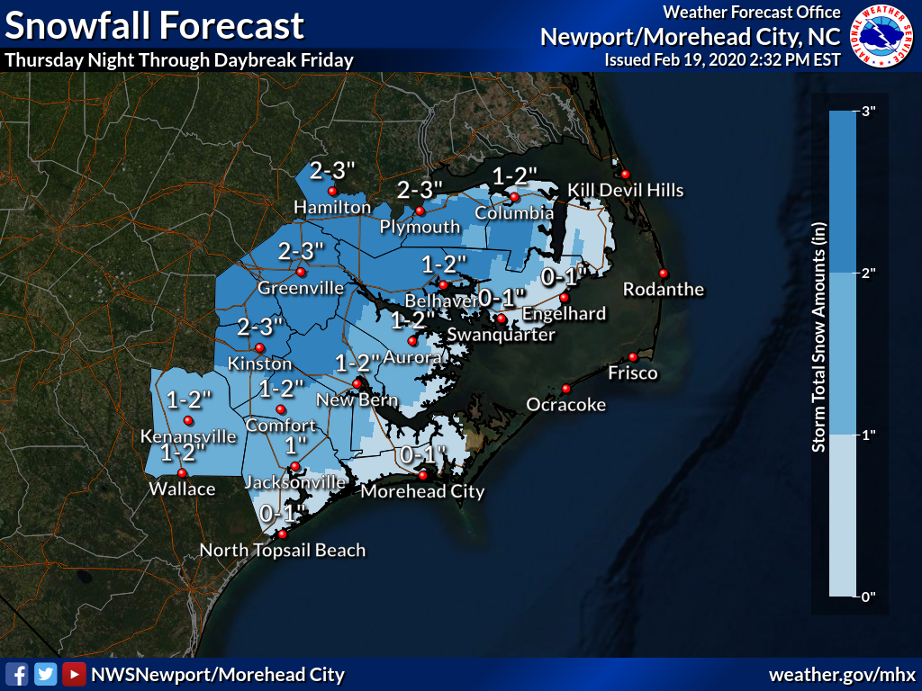
A winter coastal storm is expected to impact northeastern North Carolina Thursday night and Friday morning.
The National Weather Service has issued a Winter Storm Advisory for mainland Dare County and a Winter Storm Watch for Tyrrell and mainland Hyde County.
As of Wednesday afternoon, no advisories have been issued for Hatteras and Ocracoke islands. Snow is not expected on the two islands as the temperatures are predicted to remain between 39 to 41 degrees.
For offshore and Pamlico Sound waters, a small craft warning is now in effect. A Gale Watch kicks in Thursday afternoon through Friday. Very rough waters are expected.
North to north northeast winds will blow up to 35 miles per hour with gusts to 47 along the Outer Banks.
High surf is predicted north of Cape Hatteras. Potential for minor coastal flooding exists along southern Pamlico Sound, reports the National Weather Service.
Winds are predicted to dwindle by Saturday morning and shift northwest Saturday night.
As to snow, the National Weather Service has revised its forecast upward.
The official forecast calls for two to three inches of snow west of U.S. 17; up to two inches in Aurora; and up to one inch in Engelhard and mainland Dare villages.
The winter storm will impact the entire state. As of Wednesday afternoon, a Winter Weather Advisory has been issued for portions of Western and Central North Carolina through Friday morning.
READ ABOUT MORE NEWS AND EVENTS HERE.
RECENT HEADLINES:
Nags Head commissioners approve site plan for cancer infusion facility
More News


SportsPlus
Where to Watch New Jersey Devils vs. Washington Capitals on TV or Streaming Live – October 19
The New Jersey Devils (5-2) take on the Washington Capitals (2-1) as a part of Saturday’s NHL action,…
October 19 NHL TV Schedule: TV Channel, Start Times & Live Streaming Options
The New York Rangers versus the Toronto Maple Leafs is a game to catch on a Saturday NHL…
Devils vs. Capitals Injury Report Today – October 19
Here’s a look at the injury report for the New Jersey Devils (5-2), which currently has five players…
Best Bets, Odds for the Commanders vs. Panthers Game – Week 7
Check out best bets as the Carolina Panthers (1-5) will try to break a three-game losing streak when…
Best Bets, Odds for the Panthers vs. Commanders Game – Week 7
The Carolina Panthers (1-5) take a three-game losing streak into a matchup with the Washington Commanders (4-2) on…
-
Polls
 Loading ...
-
-