Dare County warns about coastal flooding and NC 12 impact
Published 11:46 am Friday, September 18, 2020

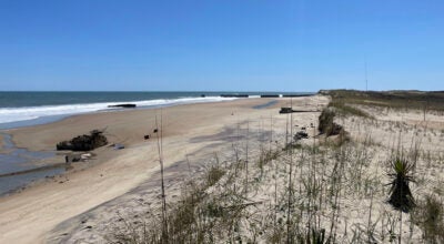
Standing water on NC-12 near Pea Island National Wildlife Refuge Visitor Center. Courtesy CHNS

Standing water on NC-12 in Waves. Courtesy CHNS

Standing water on NC-12 north of Ramp 67 on Ocracoke Island. Courtesy CHNS
|
Getting your Trinity Audio player ready...
|
Portions of the Outer Banks — particularly Hatteras Island — are expected to experience coastal flooding, high winds, storm surge, beach erosion and strong rip currents as the remnants of Sally pass over the area and the impacts from distant Hurricane Teddy are felt throughout the weekend.
The National Weather Service at Newport/Morehead City reports that high astronomical tides will bring the threat of coastal flooding around the time of each high tide on Friday, Saturday and Sunday. Friday evening’s high tide will occur at approximately 9 p.m., Saturday’s high tides will take place at approximately 9 a.m. and 10 p.m. and Sunday morning’s high tide will be around 10 a.m.
Dare County Emergency Management is asking visitors to be mindful of Hurricane Teddy and the remnants of Sally and is encouraging travelers to and from Hatteras Island to consider leaving early or to adjust their arrival and departure times to avoid high tide.
Ocean overwash along areas of N.C. Highway 12 on Hatteras Island could cause temporary closures of the roadway during periods of high tide. Those residing within oceanfront properties are advised to take action to protect their property from flooding.
Minor to moderate coastal flooding is forecast to occur with 2-4 feet of inundation likely. Strong winds beginning on Friday and extending into the weekend could bring more extensive coastal flooding impacts.
In addition to the impacts the area will see from the remnants of Sally, strong, long-period swell from Hurricane Teddy — which is currently a Category 4 hurricane headed for Bermuda — will also bring an increased potential for significant beach erosion and ocean overwash as the storm passes well offshore of the Outer Banks late Sunday and into Monday.
Strong winds and rough surf will also result in an increased risk of strong rip currents. Even the most experienced swimmers are advised to stay out of the ocean due to the dangerous surf conditions that will be created in all areas of Dare County throughout the weekend.
For weather information, visit the National Weather Service at Newport/Morehead City at www.weather.gov/mhx. For information regarding road conditions on N.C. Highway 12, follow the North Carolina Department of Transportation on Facebook at www.facebook.com/NCDOTNC12, on Twitter @NCDOT_NC12 or visit drivenc.gov.
Late Friday morning, Cape Hatteras National Seashore reported standing water in several areas along NC 12, including near the visitor center on Pea Island, in the tri-villages and at the north end of Ocracoke Island.
“Road conditions are expected to worsen due to large swells from distant Hurricane Teddy, northeasterly winds, and high astronomical tides,” stated the CNHS post, which also advised that ocean overwash may occur at the following Cape Hatteras National Seashore locations:
– South of the Basnight Bridge to the Pea Island Visitor Center,
– Mirlo Beach area, on the northern edge of the tri-villages,
– South of the Avon Pier along Ocean View Drive,
– At the north end of Buxton,
– Between Frisco and Hatteras Village,
– Along Pole Rd, south of Ramp 55, and
– Along the north end of Ocracoke island.
READ ABOUT MORE NEWS AND EVENTS HERE.
RECENT HEADLINES:
NCDOT: Bigfoot Slough dredging tentatively scheduled for next week
More News


SportsPlus
How to Watch the MLB Baseball Playoffs on Saturday, Oct. 19: TV Channel, Live Streaming, Start Times
The New York Yankees and the Cleveland Guardians square off in one of many exciting matchups on the…
MLB Playoff Betting Lines and Picks Today | Oct. 19
The New York Yankees and the Cleveland Guardians hit the field in one of many exciting matchups on…
Buy Tickets for New Jersey Devils vs. Washington Capitals on October 19
The New Jersey Devils and Washington Capitals square off at Prudential Center on Saturday, October 19 at 7:00…
Will Connor McMichael Score a Goal Against the Devils on October 19?
For people looking to place a bet on the upcoming game between the Washington Capitals and the New…
Will Alexander Ovechkin Score a Goal Against the Devils on October 19?
In the upcoming matchup versus the New Jersey Devils, which starts at 7:00 PM ET on Saturday, can…
-
Polls
 Loading ...
-
-