Court of Appeals rejects appeal on Rodanthe bridge; demolition of old Oregon Inlet bridge explained
Published 11:34 am Saturday, January 26, 2019
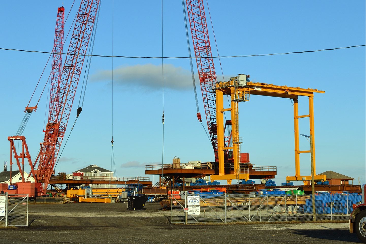
- Rodanthe Bridge work site at southern end of the project with one straddle or gantry crane. Another crane will be added at this site and two more at the northern start of the project, which is expected to be completed by April 28, 2020. Mary Helen Goodloe-Murphy photo
A three-judge panel of the Fourth Circuit Court of Appeals has unanimously rejected the appeal from Save our Sound OBX regarding the Rodanthe bridge.
The decision was published Jan. 23, 2019.
The 2.4 mile Rodanthe bridge, called the jug handle or fish hook bridge, is designed to avoid the frequently overwashed S-turns on NC 12 at the southern end of the Pea Island National Wildlife Refuge. As designed, the bridge crosses refuge land, curves out into the Pamlico Sound and returns to Hatteras Island in Rodanthe.
The Save our Sound OBX group represents property owners along the Pamlico Sound shoreline. Six individual property owners in northern Rodanthe are also part of the lawsuit.
The Rodanthe bridge is part of Oregon Inlet bridge replacement project. The Save our Sound group argued that the underlying documents for the Oregon Inlet bridge project did not address the environmental costs of the Rodanthe bridge.
The appealed U.S. District Court decision rejected that argument saying that a 2016 environmental assessment met requirements and that the project could proceed while the appeal was ongoing.
The plaintiffs also argued that the bridge could disturb Pappy Lane shipwreck, recently identified as related to two classes of World War II gunboats, Landing Craft Infantry and Landing Craft Support vessels.
Mark Haines with Save our Sound OBX said, “Obviously, we are disappointed in the outcome. We’re thinking about what to do next.”
Save our Sound OBX and the individuals filed the lawsuit against the North Carolina Department of Transportation and the Federal Highway Administration. Intervening in the lawsuit as defendants are Defenders of Wildlife and the National Wildlife Refuge Association, represented by the Southern Environmental Law Center.
Derb Carter, director of the North Carolina offices of the Southern Environmental Law Center, called the moving this portion of NC 12 “a well-reasoned, common sense solution to avoid the frequent shutdowns of Highway 12 . . .”
Carter, in the prepared media release also said, “NCDOT should plan now to start moving more threatened sections of the highway out of the refuge and into the sound, to ensure this lifeline remains safe and reliable for residents and tourists while preserving the refuge at the same time.”
Current Rodanthe Bridge Status
The lawsuit did not stop some work on the new bridge project.
At the north end of the project in refuge, a 3,500-foot section of roadway for NC 12 is under construction east of the existing travel lanes. Vehicular traffic on NC 12 will be diverted to the new section while the old route is used for construction staging.
In Rodanthe in a large construction yard, a trestle bridge is under construction. The most recent feature is a big yellow piece of equipment called a straddle or gantry crane. Another gantry will be added to the Rodanthe skyline soon. Two more of the cranes will be at the northern end of the project. The two cranes will ride a rail on the trestle bridge to move pilings and girders into place.
The contractor for the project is Flatiron Construction. The contract is for $145,336,271 and, so far, 29 percent has been spent. The expected completion date is April 28, 2020.
As to the Pappy Lane wreck, the bridge will come close to the wreck. A portion of the bridge will be over the wreck, reports NCDOT resident engineer Pablo Hernandez.
The partial federal government shutdown has held up a permit from the U.S. Coast Guard and the permanent easement deeds from the National Park Service and the U.S. Fish and Wildlife Service.
Oregon Inlet Replacement Bridge
At the Jan. 22 meeting of the Dare County Board of Commissioners, state transportation board member Allen Moran addressed questions about demolition process for the existing Bonner Bridge.
Preparation for the demolition will start as soon as traffic moves to the new bridge. Demolition must be coordinated with utilities.
Demolition will take about a year, said Moran. Teams will start at the north and south ends of the old bridge. Moran indicated that the start will be “as close as possible to deep water.” In the most recent Army Corps of Engineers navigation survey, it appears that deep water starts about 600 feet south of the high rise spans.
The bridge material will be lowered onto barges and taken to off-shore reefs. The reefs and percentage of material planned for each are AR-130 (15%), AR-140 (15%), AR-145 (15%), and AR-160 (55%), which are listed as the four Outer Banks reefs.
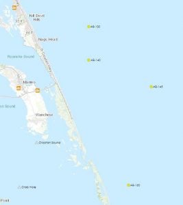
Outer Banks artificial reefs where material from the demolition of the old Oregon Inlet bridge will be placed. The reefs and percentage of material planned for each are AR-130 (15%), AR-140 (15%), AR-145 (15%), and AR-160 (55%). North Carolina Division of Marine Fisheries map
Also at the Jan. 22 meeting, James Fletcher spoke during public comment. He asked the Dare County Board of Commissioners to partner with the National Park Service to survey the southern portion of Bodie Island. Fletcher thinks that he and the Estate of W.A. Worth own the spit. If so, the private property could be used to build a structure to stabilize Oregon Inlet.
Commissioner Jim Tobin said “it’s worth taking a look at.”
RELATED:
Herbert C. Bonner Bridge opening delayed
Manteo wants new bridge named for Basnight
Grant funds new artificial reef south of Oregon Inlet
More News


SportsPlus
Old Dominion vs. Georgia State Oct. 12 Tickets & Start Time
Sun Belt foes will square off when the Georgia State Panthers and Old Dominion Monarchs meet on Saturday,…
How to Watch the MLB Baseball Playoffs on Monday, Oct. 7: TV Channel, Live Streaming, Start Times
The Kansas City Royals and the New York Yankees hit the field in one of many exciting matchups…
MLB Playoff Betting Lines and Picks Today | Oct. 7
The MLB Playoff outings in a Monday lineup that shouldn’t be missed include the Kansas City Royals playing…
CAA Football Power Rankings for Week 7
With Week 7 of the college football schedule upon us, which teams are the leading contenders at the…
MEAC Football Power Rankings for Week 7
Looking at the schools in the MEAC, who are the top teams in the conference entering Week 7…
-
Polls
 Loading ...
-
-