Eye of Dorian just east of Cape Lookout
Published 6:15 am Friday, September 6, 2019
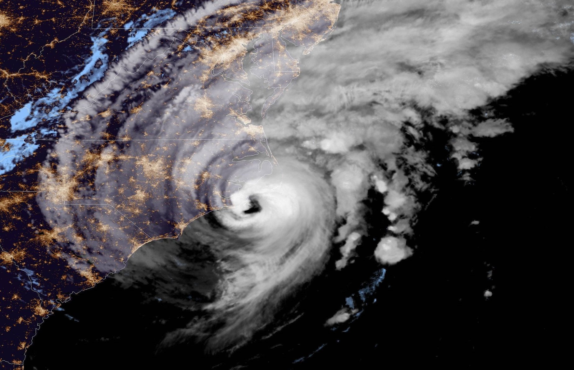
- NOAA image
Hurricane conditions are spreading northward along portions of the North Carolina coast. Tropical storm conditions are still affecting the northern portion of the South Carolina coast. A Hurricane Warning is in effect for Little River Inlet to the North Carolina/Virginia border and the Pamlico and Albemarle sounds.
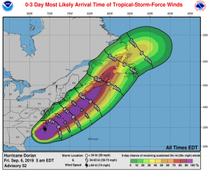
NOAA image
As of the National Hurricane Center’s 5 a.m. update Friday, September 6, Hurricane Dorian is centered just east of the North Carolina coastline about 25 miles east of Cape Lookout and about 55 miles southwest of Cape Hatteras. It is moving toward the northeast near 14 mph and this general motion with an increase in forward speed is expected through Saturday. On the forecast track, the center of Dorian will move near or over the coast of North Carolina during the next several hours. The center should move to the southeast of extreme southeastern New England Friday night and Saturday morning and then across Nova Scotia late Saturday or Saturday night.
Maximum sustained winds are near 90 mph with higher gusts. Dorian should remain a powerful hurricane as it moves near or along the coast of North Carolina during the next several hours. Dorian is forecast to become a post-tropical cyclone with hurricane-force winds by Saturday night as it approaches Nova Scotia.
Hurricane-force winds extend outward up to 45 miles from the center and tropical-storm-force winds extend outward up to 220 miles. A NOAA weather station at Cape Lookout located inside the western eyewall of Dorian has reported sustained hurricane-force winds of 74 mph and a gust to 94 mph. This is equivalent to a 1-minute sustained wind speed of 81 mph. A Weatherflow station at Fort Macon near Atlantic Beach recently reported a sustained wind of 64 mph and a gust to 85 mph.
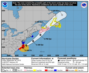
NOAA image
A Storm Surge Warning is in effect for:
• Surf City to Poquoson, Va.
• Pamlico and Albemarle Sounds
• Neuse and Pamlico Rivers
• Hampton Roads
NHC forecasts indicate water could reach the following heights above ground somewhere in the indicated areas if the peak surge occurs at the time of high tide:
Surf City to Duck, including Pamlico and Albemarle sounds and the Neuse and Pamlico Rivers…4 to 7 ft
Duck to Poquoson Va., including Hampton Roads…2 to 4 ft
Dorian is expected to produce the following rainfall totals through Saturday:
Northeastern North Carolina…Additional 3 to 8 inches, isolated storm totals 15 inches.
Far southeast Virginia…3 to 8 inches.
Extreme Southeastern New England…2 to 4 inches.
Nova Scotia and Prince Edward Island…3 to 5 inches.
New Newfoundland…1 to 2 inches
This rainfall may cause life-threatening flash floods.
A Hurricane Watch is in effect for Nova Scotia
A Tropical Storm Warning is in effect for:
• South Santee River, SC to Little River Inlet
• North Carolina/Virginia border to Fenwick Island DE
• Chesapeake Bay from Drum Point southward
• Tidal Potomac south of Cobb Island
• Woods Hole to Sagamore Beach, Mass.
• Nantucket and Martha’s Vineyard, Mass.
Tropical storm conditions are expected in the Tropical Storm Warning area in the Mid-Atlantic states later Friday and over portions of extreme southeastern Massachusetts Friday night or early Saturday.
A Tropical Storm Watch is in effect for:
• Prince Edward Island
• Magdalen Islands
• Fundy National Park to Shediac.
• Francois to Boat Harbour.
The next complete advisory will be issued by NHC at 5 a.m. with an intermediate advisory at 8 a.m. – www.hurricanes.gov
READ ABOUT MORE NEWS AND EVENTS HERE.
RECENT HEADLINES:
Dare County Emergency Management advising it is too late to evacuate; shelter in place
More News


SportsPlus
How to Pick the Flyers vs. Capitals Game with Odds, Spread, Betting Line and Stats – October 22
If you’re searching for best bets for the Philadelphia Flyers’ upcoming contest against the Washington Capitals on Tuesday…
Old Dominion vs. Georgia Southern Oct. 24 Tickets & Start Time
The Old Dominion Monarchs and Georgia Southern Eagles will clash on Thursday, October 24, 2024 at Kornblau Field…
MEAC Football Power Rankings for Week 9
With Week 9 of the college football schedule upon us, which teams are the leading contenders at the…
Sun Belt Football Power Rankings for Week 9
Week 9 of the college football schedule is here. To find out how every Sun Belt team stacks…
CAA Football Power Rankings for Week 9
As we head into Week 9 of the college football schedule, which team sits on top of the…
-
Polls
 Loading ...
-
-