Isaias becomes tropical storm, earliest ninth Atlantic named storm
Published 9:45 am Thursday, July 30, 2020

- NOAA image
|
Getting your Trinity Audio player ready...
|
Potential Tropical Cyclone Nine became Tropical Storm Isaias last night, July 29, and the National Weather Service reports it is causing heavy rain and high winds over Puerto Rico.
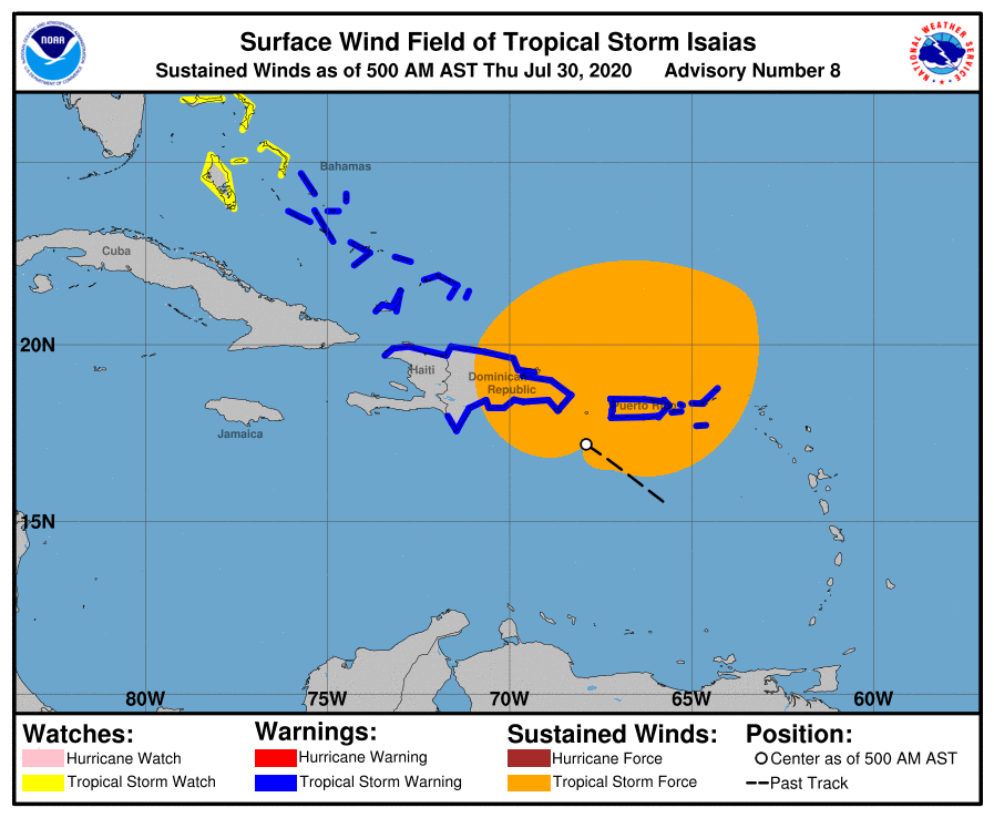
Currently, a Tropical Storm Warning is in effect for Puerto Rico, Vieques, Culebra, U.S. Virgin Islands, British Virgin Islands, Dominican Republic entire southern and northern coastlines, North coast of Haiti from Le Mole St Nicholas eastward to the northern border with the Dominican Republic, Turks and Caicos Islands, Southeastern Bahamas including the Acklins, Crooked Island, Long Cay, the Inaguas, Mayaguana, and the Ragged Islands, Central Bahamas, including Cat Island, the Exumas, Long Island, Rum Cay and San Salvador.
A Tropical Storm Watch is in effect for Northwestern Bahamas including Andros Island, New Providence, Eleuthera, Abacos Islands, Berry Islands, Grand Bahamas Island and Bimini.
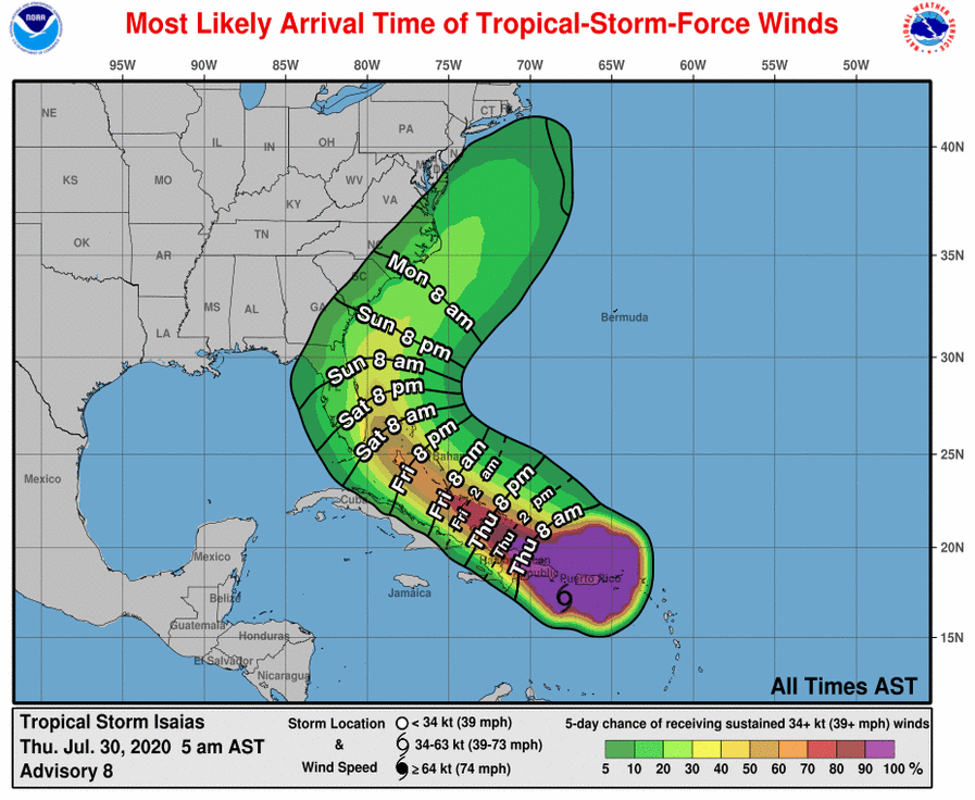
The NWS National Hurricane Center is calling for tropical storm conditions to continue across portions of the Leeward Islands, the U.S. and British Virgin Islands and Puerto Rico overnight. Conditions are forecast to reach portions of the Dominican Republic and Haiti within the warning area by this morning and the southeastern Bahamas and Turks and Caicos this afternoon. Tropical storm conditions are expected in the Central Bahamas beginning Friday morning, July 31 and are possible in the northwestern Bahamas beginning late Friday.
Interests in Cuba and the Florida peninsula should monitor the progress of this system, according to NWS.
At 5 a.m. AST, the center of Tropical Storm Isaias was located over the Caribbean Sea about 100 miles (225 km) west-southwest of Ponce, Puerto Rico and about 160 miles (255 km) southeast of Santo Domingo, Dominican Republic. The system is moving toward the northwest near 21 mph (33 km/h), and a west-northwestward to northwestward motion with some decrease in forward speed is expected over the next couple of days. On the forecast track, the center of Isaias will move over Hispaniola late today and near the Southeastern Bahamas by early Friday.
Maximum sustained winds are near 60 mph (95 km/h) with higher gusts. Tropical-storm-force winds extend outward up to 415 miles (665 km) from the center. A Weatherflow station in Yabucoa Tanque de Agua reported sustained winds of 52 mph (83 km/h) with a gust to 59 mph (94 km/h). Little change in strength is anticipated until landfall in Dominican Republic later today, with re-strengthening forecast on Friday and Saturday.
Isaias is expected to produce the following rain accumulations:
– British and U.S. Virgin Islands and Turks and Caicos: 3 to 6 inches.
– Puerto Rico and northern Haiti: 3 to 6 inches, with isolated maximum totals of 8 inches.
– Dominican Republic: 4 to 8 inches, with isolated maximum totals of 10 inches.
– Bahamas: 4 to 8 inches.
– Cuba: 2 to 4 inches, with isolated maximum totals of 6 inches.
NWS cautions these rainfall amounts could lead to life-threatening flash flooding and mudslides, as well as potential riverine flooding beginning Thursday. Urban and small stream flooding is expected for the U.S. Virgin Islands, eastern Puerto Rico and Hispaniola.
Isaias is the earliest ninth Atlantic named storm to form, according to Colorado State University hurricane researcher Phil Klotzbach. The previous record was Irene on August 7, 2005, Klotzbach tweeted.
READ ABOUT MORE NEWS AND EVENTS HERE.
RECENT HEADLINES:


