Keeping an eye on Tropical Storm Dorian
Published 7:39 am Monday, August 26, 2019
- NOAA image
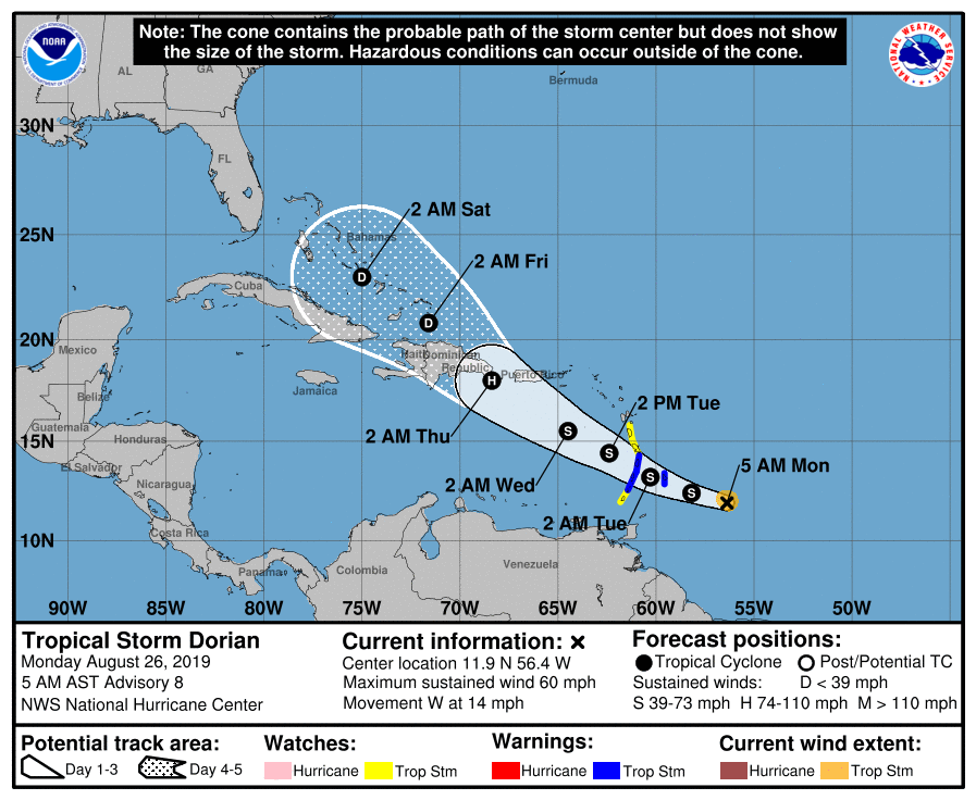
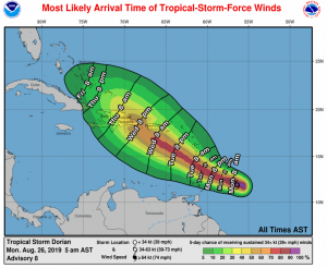
According to the 5 a.m. update from the National Hurricane Center on August 26, Tropical Storm Dorian is expected to bring tropical storm conditions to parts of the Lesser Antilles, where tropical storm warnings and watches are already in effect.
The storm is expected to bring 2 to 4 inches of rain – and isolated amounts as much as 6 inches – to Barbados, the Windward Islands and Dominica. Possible impacts to Puerto Rico, the Virgin Islands and Hispaniola are being monitored.
NOAA image
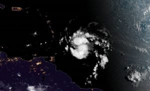
Dorian, a small tropical cyclone, has maximum sustained winds near 60 mph with higher gusts with tropical storm force winds extending outward up to 45 miles from the center. The NHS forecast shows slow strengthening during the next few days and Dorian could be near hurricane strength on Tuesday and Wednesday while it is over the eastern Caribbean Sea.
NOAA image
Tropical Storm Dorian is centered as of 5 a.m. Monday about 225 miles east-southeast of Barbados and moving toward the west near 14 mph. A turn toward the west-northwest is expected later Monday, with this motion continuing through Tuesday night.
While it is too soon to tell what, if any, impact Dorian will have on the Outer Banks, this is a good time to make sure your storm preparation plan is in place. Check out our 2019 Disaster Preparedness Guide here for more information. For updates, check back here or hurricanes.gov.
At this time, there is also an elongated area of low pressure centered about 280 miles south-southeast of Cape Hatteras that has become better organized Monday morning. Conditions appear conducive for gradual development and a tropical or subtropical cyclone is likely to form Monday or Tuesday while the system moves slowly northeastward well offshore of the southeastern United States.
READ ABOUT MORE NEWS AND EVENTS HERE.
RECENT HEADLINES:
More News


SportsPlus
Chiefs, 49ers, Week 5 NFL Power Rankings
Heading into Week 5 of the NFL schedule, let’s dig into our freshly updated power rankings, which dissect…
Discover the Best Week 5 NFL Player Prop Bets & Odds
The New Orleans Saints versus the Kansas City Chiefs is a game to catch on a Week 5…
Orioles vs. Royals: Betting Preview for AL Wild Card Game 1
Game 1 of the Wild Card round is set for Tuesday, Oct. 1 at Oriole Park at Camden…
How to Watch the MLB Baseball Playoffs on Tuesday, Oct. 1: TV Channel, Live Streaming, Start Times
The MLB Playoff outings in a Tuesday lineup that shouldn’t be missed include the New York Mets squaring…
How to Watch the Orioles vs. Royals Game: Streaming & TV Channel Info for AL Wild Card Game 1
The AL Wild Card Series begins on Tuesday when the Baltimore Orioles play host to the Kansas City…
-
Polls
 Loading ...
-
-